


Le Vey/Pain de Sucre et rochers des Parcs

geoffrayLayeux
User
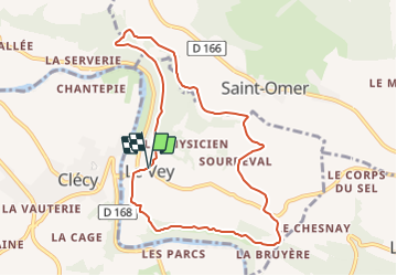

Length
8.5 km

Max alt
248 m

Uphill gradient
255 m
Km-Effort
11.9 km

Min alt
37 m

Downhill gradient
259 m
Boucle
Yes
Creation date :
2021-12-12 16:02:49.052
Updated on :
2021-12-12 16:03:52.697
2h42
Difficulty : Medium

FREE GPS app for hiking
 SityTrail
IGN / Geographical institutes
SityTrail Plus
The world is yours!
About
Trail Walking of 8.5 km to be discovered at Normandy, Calvados, Le Vey. This trail is proposed by geoffrayLayeux.
Positioning
Country:
France
Region :
Normandy
Department/Province :
Calvados
Municipality :
Le Vey
Location:
Unknown
Start:(Dec)
Start:(UTM)
685266 ; 5421346 (30U) N.
Comments